|
Accurate maps
of Laurence Harbor are hard to come by, partly because what Laurence
Harbor is. Contrary to popular belief, Laurence Harbor is not a
city, town, village, hamlet or any other incorporated jurisdiction
whatsoever. It is simply a longstanding neighborhood of Old Bridge
on the banks of the old Raritan.
Because of the
lack of official jurisdictional boundaries, usually friendly arguments
over where Laurence Harbor ends and another neighborhood begins
do occur.
LH's longstanding
identity prompted the Census Bureau to define Laurence Harbor as
a census-designated place (CDP). This means that much Census data
is tabulated for just Laurence Harbor. (For more info on CDP's,
see the wiki entry http://en.wikipedia.org/wiki/Census-designated_place.)
It also means that a Census map exists for Laurence Harbor, although
as you will see, there are problems with its boundaries.
The first thing
you should notice about the map is that it stretches from the Sayreville
boundary on the northwestern boundary of Old Bridge to the Aberdeen
boundary on the southeastern side of Old Bridge. Most people with
a knowledge of the area know that the Blvd West, Furman Blvd and
Ocean Blvd area is actually part of Cliffwood Beach and not Laurence
Harbor. Cliffwood Beach is another neighborhood of Old Bridge.
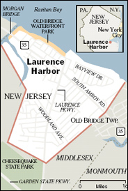
In the map above,
Laurence Harbor is more accurately defined according to traditional
local understanding. However, a new point of discussion comes up.
In the southwest portion of Laurence Harbor, the above map ends
at the boundary of Cheesequake State Park, leaving out the entire
Bridgepointe development. Who cares? People who sell real estate
want it included because its $400,000 townhomes raise the status
and property value of the entire area. LH old timers (self-labeled,
we stress) say that the neighborhoods are different enough to be
considered seperately.
|